drone photography

Remembrance Poppy Display – St Annes Parish Church

Photo of St Annes Church in Lytham St Annes with a cascade of red poppies flowing from the tower for Remembrance Day
Drone photo of St Annes Church in Lytham St Annes with a cascade of red poppies flowing from the tower for Remembrance Day

Today we remember - those who paid the ultimate price 🎖️,

and the many, many more who’ve quietly checked themselves out since.

You are not forgotten.

Those still fighting their battles.

You are not on your own.

Please talk.

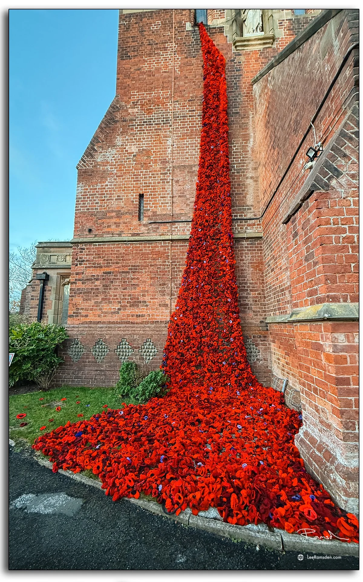
Each year, the Remembrance period brings a powerful stillness to communities across the UK — a pause to reflect on the lives lost in conflict. This striking poppy display at St Annes Parish Church does exactly that.

Thousands of handmade poppies cascade from the church tower to the ground, symbolising the ongoing flow of remembrance from generation to generation. Seen from above, the red trail cuts through the old brickwork and gravestones — a vivid reminder of sacrifice and resilience.

The installation was created by local volunteers, each poppy representing care, memory, and community effort.

Dunnottar Castle Sunrise – Drone Photography in Stonehaven, Scotland

Drone photograph of Dunnottar Castle at sunrise in Stonehaven, Scotland, showing the ruins on cliffs above the North Sea.

Few locations on Scotland’s east coast carry as much atmosphere as Dunnottar Castle. Perched high above the North Sea, the ruins dominate the headland and remain one of the country’s most iconic coastal landmarks.

Captured by drone at sunrise, the first light revealed texture in the stonework and depth across the cliffs. The dramatic shadows emphasise both the scale of the castle and the rugged coastline that surrounds it.

The surviving buildings are largely from the 15th and 16th centuries, but the site is believed to have been fortified in the Early Middle Ages.

Dunnottar is best known as the place where the Honours of Scotland, the Scottish crown jewels, were hidden from Oliver Cromwell's invading army in the 17th century.

This work adds to my wider series on Scotland’s coastal landmarks, using drone photography to document places where history and landscape meet.

Scurdie Ness Lighthouse – Coastal Photography in Montrose, Scotland

Drone photograph of Scurdie Ness Lighthouse on the Montrose coast, built in 1870 to prevent shipwrecks near the River South Esk.

Built in 1870 after numerous shipwrecks, Scurdie Ness Lighthouse stands at the mouth of the River South Esk, guiding vessels safely along the east coast of Scotland.

Photographed in freezing conditions, these images show the tower against clear skies, highlighting the engineering that still defines the Montrose shoreline today.

Scotland’s lighthouses remain some of the most practical yet visually striking coastal landmarks. This shoot adds to my ongoing series on maritime structures.

Blackpool Tower Sunrise – Coastal Photography in Lancashire

Blackpool Tower has been a landmark on the Lancashire coast since 1894. Photographed at sunrise, the tower rises above the quiet seafront before the town comes to life.

Sunrise photograph of Blackpool Tower and seafront promenade in Lancashire, England.

The images show both the tower itself and the open promenade below, with first light adding contrast and atmosphere.

This shoot continues my coastal series, recording familiar landmarks in changing light to highlight their place in the landscape.

St Annes Beach Sunset Walk – Coastal Photography in Lancashire

St Annes Beach stretches wide along the Fylde Coast, the sands running south from the pier towards the dunes. At sunset the light changes quickly — the sky shifts through orange and pink while the wet sand reflects colour back from below, and the wide beach gives walkers and silhouettes a scale that tighter shorelines cannot match.

Sunset photography of St Annes Beach in Lancashire, England, showing wide sands, silhouettes, and warm evening light.

These drone images were taken in the early evening, hovering above the beach to capture the scale of the space and the figures moving through it. The Fylde Coast has a particular quality at this time of day — it is never frantic, and in summer the evening light rewards patience.

St Annes is one of the locations I return to regularly, both as somewhere to walk and somewhere to photograph. The beach and the estuary offer different conditions each time.

For more coastal photography from Lancashire and Scotland, visit the Places gallery.

Noord Pier IJmuiden — Early-Morning Drone Photography, Netherlands

Early morning drone photo of Noord Pier, IJmuiden. Jetty structure and calm sea under pre-sunrise sky, emphasizing lines and reflection.

Predicting what dawn will bring is part of the job. This time, I cycled to Noord Pier in IJmuiden, raised my drone just before sunrise, and tried to capture how the pier looks when light, weather, and tide conspire. The difference this visit had over previous ones was in the softness of the sky and calm water, which changed how shadows and reflections behaved.

These shots show the pier’s structure against the open sea, the water reflecting the early sky, and the perspective lines of the jetty converging toward the horizon. The clean air and low tide helped turn familiar elements into more dramatic compositions.

Drone image of boardwalk and railings at Noord Pier, IJmuiden, Netherlands. Soft sky and water reflections add mood to the composition

Revisiting locations like this lets me see subtle changes in light and atmosphere. For more coastal drone work with changing conditions, check out my Places and Drone Photography galleries.

Evertsenstraat Watertoren IJmuiden — Drone Photography, Netherlands

Drone photograph of Evertsenstraat Water Tower in IJmuiden, Netherlands, showing tower and attached apartments in national monument surroundings.

The converted water tower at Evertsenstraat in IJmuiden caught my eye during a recent trip — its history, monument status, and architecture combining into something photographically interesting. What used to supply drinking water now stands as residential apartments surrounded by park-like green spaces, and the tower’s shape against sky feels different from every angle.

Aerial detail of rooftop apartments attached to former water tower at Evertsenstraat, IJmuiden, highlighting architectural shape and roof details.

The complex dates from 1914–1915. Built as a water supply complex, the tower and filter building remain as national monuments. Flying the drone above the Watertorenpark, I aimed to capture both the structure’s form and its setting — the clean lines of the tower, the geometry of the rooftop apartments, the park and landscaping around, and the sense of height.

Wide-angle drone shot of Watertorenpark green space, filter building and water tower in IJmuiden, Netherlands.

Architecture and monumentality in unexpected places is a focus of mine. For more structural drone photography in the Netherlands and beyond, check the Drone and Places galleries.

Great Orton Wind Farm — Onshore Drone & Renewables Photography

Great Orton Wind Farm, in Wigton near Carlisle, shows the power of clean energy set against the rural English landscape. These six turbines stand tall at 45 m to the hub (68.5 m to blade tip), and today’s drone shots aim to show not just their scale, but how they sit in place relative to the field, sky, and horizon.

Drone photograph of Great Orton Wind Farm, Wigton — six turbines set above farmlands with clean lines and open sky.

Flying above, I captured compositions where turbine towers puncture the skyline, blades silent but implied in motion. The open land around means little to interfere — just farm tracks, walls, and the occasional tree. Light at this time of day softens the metal surfaces, casts long shadows, and gives contrast between turbine steel and landscape texture.

Aerial close-up of turbine tower and blade at Great Orton, showing detail of structure and contrast with the sky.
Wind turbines at Great Orton with farmland patterns beneath, captured in soft early morning light.

My ongoing renewables and industrial photography seeks moments where engineering and environment combine. For more drone work in landscapes like this, check out my Drone and Wind Industry galleries.

IJmuiden, Seaport Beach — Drone Photography, Netherlands

Golden hour drone image of IJmuiden seaport beach, sunset reflections on wet sand and silhouettes of breakwaters.

Golden hour over IJmuiden’s seaport beach gives light a rare softness — when metal, sand, and sea all respond with reflection. These drone shots capture that brief moment when the elements line up at the edge of sunset.

Port cranes and shipping structures glowing under sunset light at IJmuiden, capturing industrial silhouette.

Flying over the beach and port area, I watched how the light changes the textures — wet sand mirrors sky, breakwaters cast long silhouettes, shipping containers and cranes glow faintly in warm tones. Each image is about contrast: structure against horizon; calm water against the industrial edges of the seaport. Golden hour makes everything more dramatic without forcing it.

Beach shoreline and port infrastructure at IJmuiden, Netherlands, seen from above with calm water and warm sky.
Combination of natural and industrial in IJmuiden: sand, sea walls and warm sunset light at seaport edge.

These images are part of my ongoing exploration of shorelines and port environments. For more coastal and industrial drone work, see my Drone and Wind Industry galleries.

Stadhuis, City Hall, van Velsen, IJmuiden, Netherlands — Drone Architecture Photography

Drone photograph of IJmuiden City Hall (Stadhuis), taking in flat roof design, modern architecture and contrast with local urban layout.

The Stadhuis (City Hall) in IJmuiden stands out among local architecture — its design contrasts sharply with surrounding Dutch styles. Taking these drone shots, I aimed to show that difference: form, angles, and how this building interacts with space around it under open skies.

Flying above, the images capture City Hall’s clean lines, flat roofing, and the mix of materials that make it visually distinct. Shadows fall sharply across facades; geometric shapes play with negative space. Where local architecture tends toward gabled roofs and traditional colour tones, this building’s style emphasises modernism and function. The aerial view lets you see its relationship to nearby streets, plots, and the way light hits its structure from different angles.

Close aerial image of facade and window geometry at IJmuiden Stadhuis, emphasising modern style and bold architectural lines.

Buildings like this break from the expected, offering contrast in form and style. For more architectural and drone photography exploring such design variety, see my Places and Drone galleries.

Zuidpier, IJmuiden — Early-Morning Drone Photography, Netherlands

Early morning drone photograph of Zuidpier IJmuiden; pier boardwalk and railing extend into calm sea under pastel sky.

Light and weather turn the same pier into a different subject every time. At Zuidpier, IJmuiden, those early-morning skies sharpened the pier’s structure against calm sea, bringing out contrast and texture where grey mornings before felt flat.

Pier structure and sea wall at Zuidpier IJmuiden, showing reflections in water and textured surfaces in or near dawn light.
Akka, Sailing yacht, IJmuiden, Netherlands

These drone images capture the pier extending into the North Sea, boardwalks, railings, and sea walls outlined against reflective water. Light played across metal and concrete surfaces, changing perspective and bringing out details in shadow and form. It shows why revisiting locations matters — the difference between dull and dramatic often comes down to weather and light.

Revisiting sites like this helps me see the same location anew. For coastal structure, reflection, and drone work, see my Places and Drone galleries.

Montrose A92 and Railway Bridges — Sunrise Drone & Structure Photography

A92 road bridge in Montrose at sunrise, drone view showing span structure and dawn light.

Bridges are found in most towns, but when the light is right, they become more than infrastructure—they turn into patterns, angles, and motion. At Montrose, using my drone at sunrise offered fresh views of the A92 and railway bridges, where structure meets transport in the early calm.

Montrose railway bridge under early sunlight, steel frame and track lines against soft sky.

From the air, the steel girders and road decks form lines against the sky; the railway tracks cut through the frame, waiting for trains to add motion. Dawn light inches across surfaces, casting long shadows and making reflections dance off metal. Watching a train pass beneath, perfectly framed among beams and spans, gives a moment of balance between still structure and movement. The set includes both wide-angle shots and tighter compositions, showing scale and detail.

Close structural detail of beams and trusses at a bridge in Montrose, showing geometric patterns.

Patiently waiting for a train to pass, does not disappoint when they come in to the scene.

Train crossing Montrose railway bridge at sunrise, framed by bridge structure and tracks.

Structure, motion, and lines are themes I return to often. For more work exploring architecture, bridges, and drone perspectives, see my Places and Drone galleries.

North Pier, IJmuiden at Early Sunrise — Drone & Coastal Morning Light, Netherlands

Early morning drone image of North Pier IJmuiden, boardwalk lines and calm water under soft sunrise sky.

When the horizon is calm and dawn breaks over the water, familiar structures take on new form. The North Pier in IJmuiden at early sunrise offered one of those moments — air cool, light soft, reflections still. Riding a bike before the workday started to catch that transition from darkness to colour made all the difference.

These images came from a session where outcomes were uncertain — sky, tide, cloud cover all played their parts. Walking or cycling toward the pier meant seeing small changes in light on railings, weathered timber, and pier surfaces. The drone lifts you above the scene: boardwalks become lines, the sea becomes a mirror, and the horizon becomes a soft gradient. Even when the result isn’t what I originally planned, I enjoy what emerges — shapes, tones, mood.

Mornings like this remind me why I chase light before day begins. For more sunrise pier, coastline, and drone work, see my Places and Drone galleries.

Montrose Quay — Early Morning Port & Industrial Photography

Wide view of Montrose Quay at sunrise, supply vessels and pier reflected in calm water.

Montrose Quay comes alive quietly in the early hours. The vessels are already moving, equipment sits ready on the dockside, and the waterfront infrastructure — cranes, bollards, quay walls — shows itself clearly in the low, raking light before the working day fully begins.

These drone images were taken in the early morning to capture the quay before it fills with activity. The River South Esk runs alongside, the railway bridge is visible in the distance, and the town sits back from the water just far enough to let the industrial character of the port read clearly.

Montrose is one of the smaller working ports on the east coast of Scotland, but it has a long maritime history connected to fishing, trade and, more recently, the offshore oil and gas and renewables sectors.

For more harbour or industrial photography, see my Places and Wind Industry galleries.

St Vigeans Church

St Vigeans Church sits on a low hill in the ancient village of St Vigeans, on the northern outskirts of Arbroath in Angus. The church is one of the older surviving ecclesiastical sites in the area — the building dates from the 12th century, though the site itself is thought to be older. It was consecrated in 1242 by David de Bernham, Bishop of St Andrews.

The village of St Vigeans takes its name from Saint Fechin of Fore, an Irish monk whose name was anglicised over centuries to Vigean. The church stands on a raised mound that may indicate even earlier pre-Christian use of the site.

These photographs are part of an ongoing project documenting churches and historic buildings across Angus and Scotland. The Church of Scotland parish still serves the local community, and the adjacent Abbots House museum holds an important collection of carved Pictish stones found in the area.

For more church photography, see the Church category in the blog and the Places portfolio.

Fairhaven United Reformed Church - The White Church

Good morning,

Here is a photo following on from my personal project of photographing Church’s.

Although officially Fairhaven United Reformed Church, this church is known locally as The White Church.

The story of the White Church begins at a meeting of the congregation of Lytham Congregational Church in 1899 with the suggestion that there should be a new church in Fairhaven on the estuary of the Ribble on land leased by the Clifton family of Lytham Hall.  A month after the proposal was made they received great encouragement for their vision.  The Congregational Union of England and Wales had commenced a fund to raise half a million guineas for church extension… ‘in view of the rapid increase in population’.

Now there was no stopping them and with scarcely a setback they began raising the money that would be required to build the new church, a church which they all agreed should be a distinctive architectural feature in the district (and it is!).

Four firms were chosen to submit designs. The successful architects were Briggs, Wolstenholme and Thornley of Blackburn who won with a design that imitated some of the features of Byzantine architecture (on the outside that is).  When the church was opened on October 17, 1912, eight years after the opening of the new church hall on May 4 1904, their vision was realised.

https://fairhavenurc.org.uk/

Thanks

Lee

St Annes Parish Church

Hello, I hope that you are well.

Today I would like to share some images taken of the Parish Church of St Annes.

The Above image was lit by attaching LumeCube lights to a drone and flown close by to illuminate different areas. Multiple exposures were taken and then blended in photoshop.

The church is from which the town took its name. It is part of the Church of England and in the Diocese of Blackburn

History

The building of St Annes Church was commissioned by Lady Clifton in the early 1870s and named in memory of her aunt who was called Anne. It was built as a chapel of ease to the then parish church of St Cuthbert in Lytham to benefit the farm labourers and fishermen of the hamlet of Heyhouses, who had difficulty in getting to church on a Sunday morning. It was several miles walk

Blackpool Promenade.

02 Promenade, Blackpool tower, Lancashire, landscape, pano, drone, dji, mavic pro 2, aerial, photography, Lytham St Annes, Lee Ramsden, sunset

Good morning.

I like to share some images of Blackpool front.

Blackpool’s sea front, with its dazzling lights and timeless charm, has been a beloved destination for generations. Stretching along the Fylde Coast, Blackpool’s sea front is famous for its piers, the iconic Blackpool Tower, and a lively promenade filled with attractions.

Promenade, Blackpool tower, Lancashire, landscape, pano, drone, dji, mavic pro 2, aerial, photography, Lytham St Annes, Lee Ramsden, sunset

Standing tall since 1894, Blackpool Tower is an enduring symbol of the city’s heritage. As the sun sets, the tower lights up, creating a spectacular sight against the evening sky.

Have you explored Blackpool Sea Front? Share your favorite photos and experiences in the comments on Instagram @lee_ramsden.

Promenade, Blackpool tower, Lancashire, landscape, pano, drone, dji, mavic pro 2, aerial, photography, Lytham St Annes, Lee Ramsden, sunset

Thanks,

Lee